Weather Alert in California
Severe Thunderstorm Warning issued February 18 at 1:26AM PST until February 18 at 2:30AM PST by NWS San Diego CA
AREAS AFFECTED: Orange, CA; Riverside, CA; San Bernardino, CA
DESCRIPTION: SVRSGX The National Weather Service in San Diego has issued a * Severe Thunderstorm Warning for... San Bernardino County in southern California... Riverside County in southern California... Orange County in southwestern California... * Until 230 AM PST. * At 124 AM PST, a band of severe thunderstorms was located near the the Los Angeles Orange County line moving slowly southeast. It will move through northern Orange County and the northwest Inland Empire through 230 AM PST. HAZARD...60 mph wind gusts. SOURCE...Radar indicated. IMPACT...Expect damage to roofs, siding, and trees. * Locations impacted include... Anaheim, Santa Ana, Riverside, Irvine, Fontana, Moreno Valley, Huntington Beach, Garden Grove, Ontario, Corona, Orange, Fullerton, Costa Mesa, Rialto, Mission Viejo, Chino, Tustin, Yorba Linda, Stanton, and Seal Beach.
INSTRUCTION: For your protection move to an interior room on the lowest floor of a building.
Want more detail? Get the Complete 7 Day and Night Detailed Forecast!
Current U.S. National Radar--Current
The Current National Weather Radar is shown below with a UTC Time (subtract 5 hours from UTC to get Eastern Time).

National Weather Forecast--Current
The Current National Weather Forecast and National Weather Map are shown below.

National Weather Forecast for Tomorrow
Tomorrow National Weather Forecast and Tomorrow National Weather Map are show below.

North America Water Vapor (Moisture)
This map shows recent moisture content over North America. Bright and colored areas show high moisture (ie, clouds); brown indicates very little moisture present; black indicates no moisture.

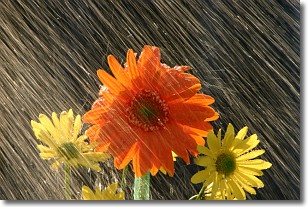
Weather Topic: What is Precipitation?
Home - Education - Precipitation - Precipitation
 Next Topic: Rain
Precipitation can refer to many different forms of water that
may fall from clouds. Precipitation occurs after a cloud has become saturated to
the point where its water particles are more dense than the air below the cloud.
In most cases, precipitation will reach the ground, but it is not uncommon for
precipitation to evaporate before it reaches the earth's surface.
When precipitation evaporates before it contacts the ground it is called Virga.
Graupel, hail, sleet, rain, drizzle, and snow are forms of precipitation, but fog
and mist are not considered precipitation because the water vapor which
constitutes them isn't dense enough to fall to the ground.
Next Topic: Rain
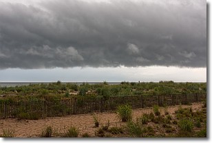
Weather Topic: What are Shelf Clouds?
Home - Education - Cloud Types - Shelf Clouds
 Next Topic: Sleet
A shelf cloud is similar to a wall cloud, but forms at the front
of a storm cloud, instead of at the rear, where wall clouds form.
A shelf cloud is caused by a series of events set into motion by the advancing
storm; first, cool air settles along the ground where precipitation has just fallen.
As the cool air is brought in, the warmer air is displaced, and rises above it,
because it is less dense. When the warmer air reaches the bottom of the storm cloud,
it begins to cool again, and the resulting condensation is a visible shelf cloud.
Next Topic: Sleet
Current conditions powered by WeatherAPI.com


