Weather Alert in California
Hydrologic Outlook issued February 20 at 1:44PM PST by NWS Medford OR
AREAS AFFECTED: Siskiyou, CA; Coos, OR; Curry, OR; Josephine, OR
DESCRIPTION: ESFMFR A moderate atmospheric river will likely bring periods of moderate to heavy rainfall later this weekend into early next week. The first frontal system is forecast to arrive late Saturday night into Sunday with multiple waves of precipitation continuing Sunday night through Tuesday morning. Preliminary estimates are showing widespread amounts of 4 to 6 inches along the coast with locally 8 inches in the favored coast ranges of Curry County. Amounts of 3 to 5 inches are possible in the Mount Shasta region and also other favored areas of western Siskiyou County. Small streams and creeks are likely to rise rapidly during this event with nuisance flooding and ponding of water on roadways during periods of heavy rain. Significant rises on main stem rivers and flashier creeks are also expected. Given that rivers are still running fairly low for this time of year, river flooding potential is a bit lower than usual, but there is at least a low probability of some flooding, especially in the Coquille Basin. While the exact scenario for the heavy rainfall and potential flooding remains uncertain, we will continue to monitor the forecasts and update accordingly. Flood Watches may be issued by the National Weather Service if this situation worsens
INSTRUCTION: N/A
Want more detail? Get the Complete 7 Day and Night Detailed Forecast!
Current U.S. National Radar--Current
The Current National Weather Radar is shown below with a UTC Time (subtract 5 hours from UTC to get Eastern Time).

National Weather Forecast--Current
The Current National Weather Forecast and National Weather Map are shown below.

National Weather Forecast for Tomorrow
Tomorrow National Weather Forecast and Tomorrow National Weather Map are show below.

North America Water Vapor (Moisture)
This map shows recent moisture content over North America. Bright and colored areas show high moisture (ie, clouds); brown indicates very little moisture present; black indicates no moisture.

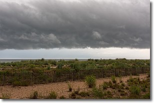
Weather Topic: What are Shelf Clouds?
Home - Education - Cloud Types - Shelf Clouds
 Next Topic: Sleet
A shelf cloud is similar to a wall cloud, but forms at the front
of a storm cloud, instead of at the rear, where wall clouds form.
A shelf cloud is caused by a series of events set into motion by the advancing
storm; first, cool air settles along the ground where precipitation has just fallen.
As the cool air is brought in, the warmer air is displaced, and rises above it,
because it is less dense. When the warmer air reaches the bottom of the storm cloud,
it begins to cool again, and the resulting condensation is a visible shelf cloud.
Next Topic: Sleet
Weather Topic: What is Snow?
Home - Education - Precipitation - Snow
 Next Topic: Stratocumulus Clouds
Snow is precipitation taking the form of ice crystals. Each ice crystal, or snowflake,
has unique characteristics, but all of them grow in a hexagonal structure.
Snowfall can last for sustained periods of time and result in significant buildup
of snow on the ground.
On the earth's surface, snow starts out light and powdery, but as it begins to melt
it tends to become more granular, producing small bits of ice which have the consistency of
sand. After several cycles of melting and freezing, snow can become very dense
and ice-like, commonly known as snow pack.
Next Topic: Stratocumulus Clouds
Current conditions powered by WeatherAPI.com


