Weather Alert in Oregon
Fire Weather Watch issued July 28 at 9:46PM PDT until July 31 at 11:00AM PDT by NWS Pendleton OR
AREAS AFFECTED: Northern Deschutes National Forest
DESCRIPTION: ...RED FLAG WARNING IN EFFECT FROM 2 PM TO 11 PM PDT TUESDAY FOR ABUNDANT LIGHTNING... ...FIRE WEATHER WATCH IN EFFECT FROM TUESDAY AFTERNOON THROUGH TUESDAY EVENING FOR ABUNDANT LIGHTNING... .Elevated fire weather concerns due to thunderstorms and continued hot and dry conditions through midweek. While these storms may produce wetting rains, there is still high confidence in the probability of isolated dry thunderstorms embedded both Tuesday and Wednesday. Daytime RHs will be in the teens to low 20s. Gusty and erratic winds can occur around thunderstorms with gusts up to 45-60 mph. The National Weather Service in Pendleton has issued a Fire Weather Watch for abundant lightning, which is in effect from Wednesday afternoon through Thursday morning. * AFFECTED AREA...Fire Weather Zone 704 Northern Deschutes National Forest. * TIMING...From Wednesday afternoon through Thursday morning. * IMPACTS...Any fire that develops will catch and spread quickly. Outdoor burning is not recommended. * THUNDERSTORMS...Scattered coverage with abundant lightning as well as 10-35% chances of dry isolated storms embedded. * OUTFLOW WINDS...Gusty erratic winds up to 45-60 mph.
INSTRUCTION: A Fire Weather Watch means that critical fire weather conditions are forecast to occur. Listen for later forecasts and possible Red Flag Warnings.
Want more detail? Get the Complete 7 Day and Night Detailed Forecast!
Current U.S. National Radar--Current
The Current National Weather Radar is shown below with a UTC Time (subtract 5 hours from UTC to get Eastern Time).

National Weather Forecast--Current
The Current National Weather Forecast and National Weather Map are shown below.

National Weather Forecast for Tomorrow
Tomorrow National Weather Forecast and Tomorrow National Weather Map are show below.

North America Water Vapor (Moisture)
This map shows recent moisture content over North America. Bright and colored areas show high moisture (ie, clouds); brown indicates very little moisture present; black indicates no moisture.

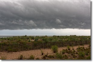
Weather Topic: What are Shelf Clouds?
Home - Education - Cloud Types - Shelf Clouds
 Next Topic: Sleet
A shelf cloud is similar to a wall cloud, but forms at the front
of a storm cloud, instead of at the rear, where wall clouds form.
A shelf cloud is caused by a series of events set into motion by the advancing
storm; first, cool air settles along the ground where precipitation has just fallen.
As the cool air is brought in, the warmer air is displaced, and rises above it,
because it is less dense. When the warmer air reaches the bottom of the storm cloud,
it begins to cool again, and the resulting condensation is a visible shelf cloud.
Next Topic: Sleet
Weather Topic: What is Snow?
Home - Education - Precipitation - Snow
 Next Topic: Stratocumulus Clouds
Snow is precipitation taking the form of ice crystals. Each ice crystal, or snowflake,
has unique characteristics, but all of them grow in a hexagonal structure.
Snowfall can last for sustained periods of time and result in significant buildup
of snow on the ground.
On the earth's surface, snow starts out light and powdery, but as it begins to melt
it tends to become more granular, producing small bits of ice which have the consistency of
sand. After several cycles of melting and freezing, snow can become very dense
and ice-like, commonly known as snow pack.
Next Topic: Stratocumulus Clouds
Current conditions powered by WeatherAPI.com


