Weather Alert in Texas
Flood Warning issued June 14 at 9:06PM CDT by NWS Houston/Galveston TX
AREAS AFFECTED: Houston, TX; Madison, TX; Trinity, TX; Walker, TX
DESCRIPTION: ...The Flood Warning continues for the following rivers in Texas... San Bernard River near Sweeny affecting Brazoria County. Trinity River near Crockett affecting Houston, Madison, Walker and Trinity Counties. Navasota River near Normangee affecting Grimes, Brazos and Madison Counties. ...The Flood Warning is extended for the following rivers in Texas... San Bernard River near Boling affecting Fort Bend, Wharton and Brazoria Counties. For the Trinity River...including Crockett, Riverside, Romayor, Goodrich, Moss Bluff, Liberty...Moderate flooding is forecast. For the Navasota River...including Normangee...Major flooding is forecast. For the San Bernard River...including Sweeny, East Bernard, Boling... Minor flooding is forecast. * WHAT...Minor flooding is occurring and minor flooding is forecast. * WHERE...Trinity River near Crockett. * WHEN...Until further notice. * IMPACTS...At 45.0 feet, Moderate lowland flooding begins in the vicinity of the gage impacting livestock grazing and prison farms. In past floods, problems occurred from the Highway 7 bridge downstream to Highway 21 bridge due to high flows in the backwater of Lake Livingston. * ADDITIONAL DETAILS... - At 8:45 PM CDT Saturday the stage was 42.0 feet. - Bankfull stage is 35.0 feet. - Recent Activity...The maximum river stage in the 24 hours ending at 8:45 PM CDT Saturday was 42.0 feet. - Forecast...The river is expected to rise to 44.6 feet early Thursday morning. Additional rises are possible thereafter. - Flood stage is 41.0 feet. - Flood History...This crest compares to a previous crest of 44.7 feet on 03/09/2001. - http://www.weather.gov/safety/flood
INSTRUCTION: Turn around, don't drown when encountering flooded roads. Most flood deaths occur in vehicles. Motorists should not attempt to drive around barricades or drive cars through flooded areas. Please report observed flooding to local emergency services or law enforcement and request they pass this information to the National Weather Service when you can do so safely. Additional information is available at www.weather.gov/hgx. The next statement will be issued Sunday afternoon at 315 PM CDT.
Want more detail? Get the Complete 7 Day and Night Detailed Forecast!
Current U.S. National Radar--Current
The Current National Weather Radar is shown below with a UTC Time (subtract 5 hours from UTC to get Eastern Time).

National Weather Forecast--Current
The Current National Weather Forecast and National Weather Map are shown below.

National Weather Forecast for Tomorrow
Tomorrow National Weather Forecast and Tomorrow National Weather Map are show below.

North America Water Vapor (Moisture)
This map shows recent moisture content over North America. Bright and colored areas show high moisture (ie, clouds); brown indicates very little moisture present; black indicates no moisture.

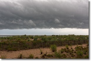
Weather Topic: What are Shelf Clouds?
Home - Education - Cloud Types - Shelf Clouds
 Next Topic: Sleet
A shelf cloud is similar to a wall cloud, but forms at the front
of a storm cloud, instead of at the rear, where wall clouds form.
A shelf cloud is caused by a series of events set into motion by the advancing
storm; first, cool air settles along the ground where precipitation has just fallen.
As the cool air is brought in, the warmer air is displaced, and rises above it,
because it is less dense. When the warmer air reaches the bottom of the storm cloud,
it begins to cool again, and the resulting condensation is a visible shelf cloud.
Next Topic: Sleet
Weather Topic: What is Snow?
Home - Education - Precipitation - Snow
 Next Topic: Stratocumulus Clouds
Snow is precipitation taking the form of ice crystals. Each ice crystal, or snowflake,
has unique characteristics, but all of them grow in a hexagonal structure.
Snowfall can last for sustained periods of time and result in significant buildup
of snow on the ground.
On the earth's surface, snow starts out light and powdery, but as it begins to melt
it tends to become more granular, producing small bits of ice which have the consistency of
sand. After several cycles of melting and freezing, snow can become very dense
and ice-like, commonly known as snow pack.
Next Topic: Stratocumulus Clouds
Current conditions powered by WeatherAPI.com


