Weather Alert in Wisconsin
Winter Storm Warning issued March 14 at 1:13PM CDT until March 15 at 10:00AM CDT by NWS Green Bay WI
AREAS AFFECTED: Wood; Portage; Waupaca; Waushara
DESCRIPTION: * WHAT...Heavy snow expected. The snow will mix with or change over to sleet, freezing rain, and rain at times late tonight through Sunday morning. Total snow and sleet accumulations between 15 and 22 inches, and ice accumulations between one and two tenths of an inch. Winds gusting as high as 50 mph may result in considerable blowing and drifting resulting blizzard conditions Sunday into Monday. * WHERE...Portage, Waushara, Wood, and Waupaca Counties. * WHEN...For the Winter Storm Warning, from 9 PM this evening to 10 AM CDT Sunday. For the Blizzard Warning, from 10 AM Sunday to 4 PM CDT Monday. * IMPACTS...Travel will become very difficult to impossible with whiteout conditions. Gusty winds could bring down tree branches and cause power outages. The Monday morning commute will be impacted.
INSTRUCTION: Travel should be restricted to emergencies only. If you must travel, have a winter survival kit with you. If you get stranded, stay with your vehicle. The latest road conditions for the state you are calling from can be obtained by calling 5 1 1. People should consider delaying all travel. If travel is absolutely necessary, drive with extreme caution. Consider taking a winter storm kit along with you, including such items as tire chains, booster cables, flashlight, shovel, blankets and extra clothing. Also take water, a first aid kit, and anything else that would help you survive in case you become stranded.
Want more detail? Get the Complete 7 Day and Night Detailed Forecast!
Current U.S. National Radar--Current
The Current National Weather Radar is shown below with a UTC Time (subtract 5 hours from UTC to get Eastern Time).

National Weather Forecast--Current
The Current National Weather Forecast and National Weather Map are shown below.

National Weather Forecast for Tomorrow
Tomorrow National Weather Forecast and Tomorrow National Weather Map are show below.

North America Water Vapor (Moisture)
This map shows recent moisture content over North America. Bright and colored areas show high moisture (ie, clouds); brown indicates very little moisture present; black indicates no moisture.

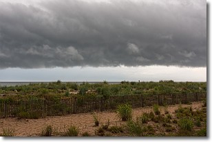
Weather Topic: What are Shelf Clouds?
Home - Education - Cloud Types - Shelf Clouds
 Next Topic: Sleet
A shelf cloud is similar to a wall cloud, but forms at the front
of a storm cloud, instead of at the rear, where wall clouds form.
A shelf cloud is caused by a series of events set into motion by the advancing
storm; first, cool air settles along the ground where precipitation has just fallen.
As the cool air is brought in, the warmer air is displaced, and rises above it,
because it is less dense. When the warmer air reaches the bottom of the storm cloud,
it begins to cool again, and the resulting condensation is a visible shelf cloud.
Next Topic: Sleet
Weather Topic: What is Snow?
Home - Education - Precipitation - Snow
 Next Topic: Stratocumulus Clouds
Snow is precipitation taking the form of ice crystals. Each ice crystal, or snowflake,
has unique characteristics, but all of them grow in a hexagonal structure.
Snowfall can last for sustained periods of time and result in significant buildup
of snow on the ground.
On the earth's surface, snow starts out light and powdery, but as it begins to melt
it tends to become more granular, producing small bits of ice which have the consistency of
sand. After several cycles of melting and freezing, snow can become very dense
and ice-like, commonly known as snow pack.
Next Topic: Stratocumulus Clouds
Current conditions powered by WeatherAPI.com


