Weather Alert in Louisiana
Flood Warning issued April 25 at 8:32PM CDT until May 13 at 3:00AM CDT by NWS New Orleans LA
AREAS AFFECTED: East Baton Rouge, LA; West Baton Rouge, LA
DESCRIPTION: ...The Flood Warning continues for the following rivers in Louisiana... Mississippi River At Reserve affecting St. James, St. John The Baptist and St. Charles Parishes. Mississippi River At Donaldsonville affecting Ascension Parish. Mississippi River At Baton Rouge affecting West Baton Rouge and East Baton Rouge Parishes. Mississippi River At Red River Landing affecting West Feliciana, Pointe Coupee and East Baton Rouge Parishes. For the Lower Mississippi River...including Red River Landing, Baton Rouge, Donaldsonville, Reserve, New Orleans...Major flooding is forecast. * WHAT...Major flooding is occurring and major flooding is forecast. * WHERE...Mississippi River at Baton Rouge. * WHEN...Until Tuesday, May 13. * IMPACTS...At 43.0 feet, Shipping and industrial activities are significantly affected. Unprotected low-lying areas will be flooded and agricultural operations will be impacted on the west side of the river. The city of Baton Rouge is protected by levees at this level. * ADDITIONAL DETAILS... - At 7:00 PM CDT Friday the stage was 41.1 feet. - Bankfull stage is 29.0 feet. - Forecast...The river is expected to rise to a crest of 42.0 feet Thursday morning. It will then fall below flood stage Monday, May 12. - Flood stage is 35.0 feet. - http://www.weather.gov/safety/flood
INSTRUCTION: Motorists should not attempt to drive around barricades or drive cars through flooded areas. Caution is urged when walking near riverbanks. Additional information is available at www.weather.gov/lix. Click on the Rivers and Lakes menu for forecasts and observations. The next statement will be issued Saturday afternoon at 1245 PM CDT.
Want more detail? Get the Complete 7 Day and Night Detailed Forecast!
Current U.S. National Radar--Current
The Current National Weather Radar is shown below with a UTC Time (subtract 5 hours from UTC to get Eastern Time).

National Weather Forecast--Current
The Current National Weather Forecast and National Weather Map are shown below.

National Weather Forecast for Tomorrow
Tomorrow National Weather Forecast and Tomorrow National Weather Map are show below.

North America Water Vapor (Moisture)
This map shows recent moisture content over North America. Bright and colored areas show high moisture (ie, clouds); brown indicates very little moisture present; black indicates no moisture.

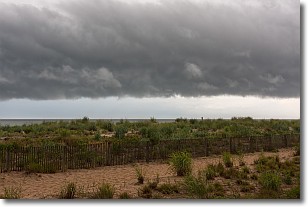
Weather Topic: What are Shelf Clouds?
Home - Education - Cloud Types - Shelf Clouds
 Next Topic: Sleet
A shelf cloud is similar to a wall cloud, but forms at the front
of a storm cloud, instead of at the rear, where wall clouds form.
A shelf cloud is caused by a series of events set into motion by the advancing
storm; first, cool air settles along the ground where precipitation has just fallen.
As the cool air is brought in, the warmer air is displaced, and rises above it,
because it is less dense. When the warmer air reaches the bottom of the storm cloud,
it begins to cool again, and the resulting condensation is a visible shelf cloud.
Next Topic: Sleet
Weather Topic: What is Snow?
Home - Education - Precipitation - Snow
 Next Topic: Stratocumulus Clouds
Snow is precipitation taking the form of ice crystals. Each ice crystal, or snowflake,
has unique characteristics, but all of them grow in a hexagonal structure.
Snowfall can last for sustained periods of time and result in significant buildup
of snow on the ground.
On the earth's surface, snow starts out light and powdery, but as it begins to melt
it tends to become more granular, producing small bits of ice which have the consistency of
sand. After several cycles of melting and freezing, snow can become very dense
and ice-like, commonly known as snow pack.
Next Topic: Stratocumulus Clouds
Current conditions powered by WeatherAPI.com


